There are three burial grounds in Borgue parish. The largest is on the outskirts of Borgue village, a second is in the picturesque hamlet of Kirkandrews, and the third is in an isolated position, inaccessible by road, in the Senwick part of the parish.
Google Street Views
The following two Google street views are of the Borgue and Kirkandrews graveyards respectively (there is no street view of Senwick graveyard).
First and Second Statistical Accounts of the Parish
Side by Side Mapping
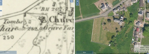
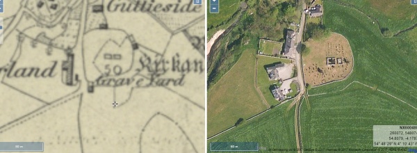
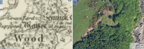
The website of the National Library of Scotland has a fascinating map viewer. Clicking on each of the images shown below will open a page showing an early Ordnance Survey map showing the old kirkyards alongside a modern satellite view of the same area. Once open, the maps can be scrolled and zoomed and different map combinations can be selected.
Borgue Church
Kirkandrews
Senwick Old Kirkyard
The Parish of Borgue used to be well known locally as “the land of milk and honey”. This description continues to be appropriate today despite the many changes in agriculture in recent years. Roughly two thirds of the land in the parish is arable, the remaining third being woodland and rough pasture. The undulating landscape is unusual and interesting, consisting of small fields bounded by dry stane dykes, with characteristic rocky outcrops or knowes scattered randomly. The fertile areas between the knowes offer excellent grazing for dairy cattle, providing milk, and the knowes are often rich in plant and insect life, providing honey. The quality of both the milk and the honey that comes from Borgue is locally known to be unrivalled.
Many of the farmhouses and steadings form attractive groups of traditional buildings which were once populated by farmers, dairymen, shepherds, stockmen and agricultural labourers. Today, many farms have been merged to form larger units resulting in many redundant steadings and houses. Increased mechanisation has also brought about a sharp fall in the numbers of people involved in agriculture. Many of the former farm cottages have been sold as homes for retired people, whilst steadings have become complexes of holiday homes as farmers seek to diversify and find new sources of income.
The parish has several miles of coastline, every part of which is of great scenic value, being indented with bays separated by rocky promontories and sometimes sheltered by trees. Ranges of high cliffs give way to grassy heughs which are rich in both flora and fauna, and the occasional small sandy beaches are much enjoyed by both local people and holidaymakers. Farmers fortunate enough to own sections of this coastline have been more fortunate than their inland colleagues in finding opportunities for diversification.
The only permanent settlement in the parish that is of any size is the village of Borgue, whose inhabitants are proud to still retain their own church, hotel and school. They also retain a strong sense of community, and thanks to the influence of a long succession of distinguished and prosperous farming families, have been able to punch well above their apparent weight in local affairs.
Nowadays, the biggest population, in the summer months at least, is to be found in caravan and holiday parks such as Brighouse Bay Leisure Park. Among its facilities are a swimming pool, a golf course, launching facilities for small boats and a well-equipped shop.
Those people in the parish of working age, who are not engaged in agriculture or tourism-related employment generally commute to Kirkcudbright, Gatehouse of Fleet, Castle Douglas, or Dumfries. Kirkcudbright’s growing fishing fleet includes several vessels owned and crewed by Borgue men, so Borgue is fast developing into “the land of milk, honey, tourists, scallops and prawns.”
David R. Collin 2010