There are two burial grounds in Buittle Parish, the older being in the church grounds, and the modern cemetery situated across the road.
Google Street Views
The following two Google street views are of the kirkyard and the cemetery respectively:
First and Second Statistical Accounts of the Parish
Side by Side Mapping
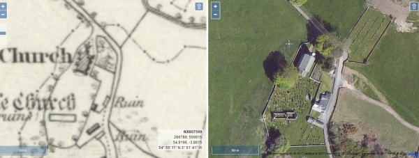
The website of the National Library of Scotland has a fascinating map viewer. Clicking on the images shown below will open a page showing an early Ordnance Survey map showing the burial grounds alongside a modern satellite view of the same area. Once open, the maps can be scrolled and zoomed and different map combinations can be selected.
A TOPOGRAPHICAL DICTIONARY OF SCOTLAND, by Samuel Lewis. Published in 2 vols, London, 1846.
“BUITTLE, a parish, in the stewartry of Kirkcudbright, 4 miles (S. E. by S.) from Castle-Douglas ; containing, with the village and port of Palnackie, 1059 inhabitants. This place is of great antiquity, and there are still some remains of its castle, supposed to have been the principal seat of the ancient lords of Galloway.
The parish, of which the name is of very uncertain derivation, is bounded on the east by the river Urr, and on the south by the bay of Orchardton, in Solway Firth ; it is about eight miles in length, and nearly three in average breadth. The surface is diversified by hill and dale ; in the middle and lower districts it is broken with numerous rocky knolls, covered with furze and broom, but in the upland districts the ground is more uniformly level, and better adapted for the plough. The soil is various, and, on the arable lands, generally fertile ; the chief crops are, oats, barley, wheat, potatoes, and turnips. The system of agriculture is improved ; the lands have been extensively drained, and large tracts of moss have been brought into profitable cultivation. Great attention is paid to the rearing of cattle, which are all of the Galloway breed, except on two or three of the dairy-farms, where those of the Ayrshire breed are preferred ; the cattle are usually sent to the English markets when three vears old. Considerable numbers of sheep are reared, and fed upon turnips, and mostly sent to Liverpool. The rateable annual value of the parish is £7757.
The plantations, which have been greatly extended within the last few years, now comprise about 96O acres. They consist chiefly of oak, ash, larch, and Scotch fir ; and on some of the lands planted at an earlier date, are remarkably fine specimens of luxuriant growth ; though many of the larches, after flourishing vigorously for a few years, degenerate. The substratum is chiefly granite, of very excellent quality, of which an extensive quarry was opened some time since, at Craignair Hill, and afforded employment to about 200 men ; blocks weighing from seven to eight tons were, for some years, shipped for Liverpool, but the quarry, at present, is only wrought to a very limited extent, for home use.
The ecclesiastical affairs are under the superintendence of the presbytery of Kirkcudbright and synod of Galloway ; the minister’s stipend is £231. 6. 2., with a manse, and a glebe valued at £20 per annum ; patron, the Crown. The church, situated in the centre of the parish, and erected in 1819, at an expense of £1000, is a handsome structure in the early English style, containing 400 sittings, and, from the height of the walls, well adapted for the erection of galleries, if additional seat room should be required. In the churchyard, are the walls of the ancient church, covered with ivy, and forming a beautiful ruin. There are two parochial schools, the masters of which, respectively, have salaries of £28 and £23, with dwelling-houses, and the fees average about £25. On a farm called Castlegower, on the north-west border of the parish, are the remains of a vitrified fort. There are two wells, formerly held in high repute, and one of which was celebrated for the cure of diseases peculiar to cattle ; but they are now totally disregarded. “