Google Street Views
The following Google street views is of Parton Kirkyard.
First and Second Statistical Accounts of the Parish
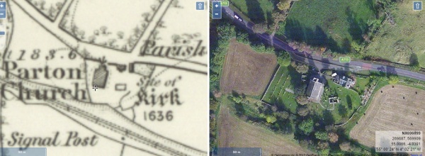
Side by Side Mapping
The website of the National Library of Scotland has a fascinating map viewer. Clicking on the image shown below will open a page showing an early Ordnance Survey map showing the burial ground alongside a modern satellite view of the same area. Once open, the maps can be scrolled and zoomed and different map combinations can be selected.
Parton Kirkyard
A TOPOGRAPHICAL DICTIONARY OF SCOTLAND, by Samuel Lewis. Published in 2 vols, London, 1846.
“PARTON, a parish, in the stewartry of Kirkcudbright, 7 miles (N. W.) from Castle-Douglas; containing 808 inhabitants, of whom 40 are in the village of Parton, and 39 in that of Corsock. This parish, which is situated nearly in the centre of the stewartry, takes its name from a Gaelic term signifying ” the Hill Top.” On the east is the river Urr, which separates it from the parish of Kirkpatrick-Durham; on the north-west, the river Ken; and on the southwest, the river Dee. It is almost seven miles in extreme length and about five miles in breadth, comprising nearly 17,000 acres, of which about 9190 are arable and pasture, 1400 woodland and plantations, and the remainder uncultivated waste. The surface towards the north is diversified with hills, but of no great elevation; the most considerable are Mochrum Fell and Cruckie Height, commanding a fine view of the vales of the Ken and the Dee, which rivers, uniting about half a mile above the village of Parton, flow together under the name of the latter into the Solway Frith. There are several lakes, of which the principal are, Corsock, Lurky, and Falbey; but none are of sufficient importance to require description. The Soil on the arable lands is light and sandy, and the chief crops are, oats, barley, and potatoes, of which last large quantities are raised ; the farms are of moderate extent, and the lands inclosed with stone dykes. Numbers of sheep and cattle, generally of the native breeds, are pastured in the hills ; and the mosses afford an ample supply of peat for fuel. A slate-quarry has been for many years in operation, producing slates of good quality for roofing; but since the reduction of the duty on English slates it has been less extensively wrought. The rateable annual value of the parish is £5210.
The principal seats are, Parton House, Corsock, and Nether Corsock, all handsome modern mansions finely situated. The villages of Parton and Corsock, though inconsiderable, are neatly built; and the surrounding scenery is pleasingly diversified. There is a post-office under that of Castle-Douglas ; and facility of communication is afforded by good roads, of which those from Castle-Douglas and Dumfries to New Galloway pass through the parish. The ecclesiastical affairs are under the superintendence of the presbytery of Kirkcudbright and synod of Galloway. The minister’s stipend is £231. 6. 2., with a manse, and a glebe valued at £25 per annum ; patroness, Miss Glendonwyn. The church, situated on the bank of the Dee, is a neat structure erected in 1834; and part of the old church, of which about one-half is still remaining, has been converted into a burial-place for the families of Glendonwyn and Maxwell. A chapel has been erected on the bank of the Urr; the minister derives his income from the seatrents and an annual donation from Mr. Fletcher, of Corsock. There are two parochial schools, of which the masters have respectively salaries of £31. 6. 6. and £20, but without either house or garden; the fees of the one average £16, and of the other £8. The number of children is about 120 in both. Near the church is an artificial mount, surrounded by a deep ditch; and about half a mile to the north of it is a larger, of similar character, about 200 yards in circumference at the base, not far from which are some Druidical remains. There are also some cairns, and at Corsock the remains of an ancient castle.”