Google Street Views
The following three Google street views are of the Twynholm kirkyard, Twynholm cemetery and The Stell old kirkyard respectively:
First and Second Statistical Accounts of the Parish
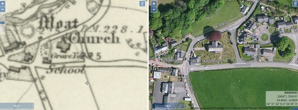
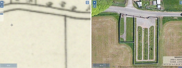
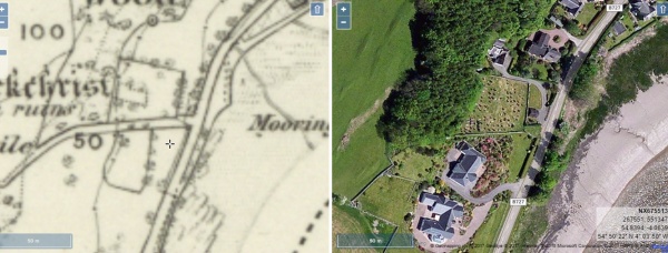
Side by Side Mapping
The website of the National Library of Scotland has a fascinating map viewer. Clicking on an images shown below will open a page showing an early Ordnance Survey map showing the burial ground alongside a modern satellite view of the same area. Once open, the maps can be scrolled and zoomed and different map combinations can be selected.
Twynholm kirkyard
Twynholm Cemetery
The Stell kirkyard
The Parish of Twynholm. This small, long but narrow parish runs roughly north and south, with the river Tarff forming the main part of its boundary to the east. It is predominantly a rural and inland parish, but does have a coastline to the estuary of the river Dee and is adjacent to, but does not include the Town of Kirkcudbright. The total land area of the parish is 10700 acres which is divided between arable land, meadow, pasture and woodland.
As in neighbouring parishes, many of the farmhouses and steadings form attractive groups of traditional buildings which were once populated by farmers, dairymen, shepherds, stockmen and agricultural labourers. Today some farms have been merged to form larger units resulting in redundant steadings and houses. Increased mechanisation has also brought about a sharp fall in the numbers of people involved in agriculture. A large number of former farm cottages have been sold as homes for retired people, and many steadings have become complexes of holiday homes as farmers seek to diversify and find new sources of income.
The village of Twynholm, which gives its name to the parish, is its historical centre and principal settlement. Today however, Kirkcudbright’s residential suburbs of Mersecroft and the Stell which are within Twynholm parish probably have the largest number of residents. The village of Twynholm is attractive and full of character and has been much improved in recent years by the construction of a bypass road which relieves it of heavy through-traffic. The village has also retained its school, church, two public houses a shop, a busy garage with petrol pumps, and a village hall and therefore has facilities which may encourage some modest expansion in future.
Most employment in the parish is to be found in agriculture, but some local employment is provided by a large haulage contractor based in Twynholm village, adjacent to the David Coulthard Museum and Pit-Stop Diner which is operated by the same family. An enterprising chocolate factory and visitor centre has also been established on the edge of the village and is proving to be a popular tourist attraction. Twynholm has become a much more attractive place to live since the bypass was completed, and now provides its inhabitants with basic facilities, a small amount of local employment and the prospect of easy commuting to Kirkcudbright, Gatehouse-of-Fleet and Castle Douglas.
David R. Collin 2010